

Arica (Chile)
Cruise Port schedule, live map, terminals, news
Region
South America
Local Time
2026-10-19 08:35
 67°F
67°F 19.4°C

 Light breeze
2.1 m/s
 73 °F / 23 °C
 63 °F / 18 °C
Port Arica cruise ship schedule shows timetable calendars of all arrival and departure dates by month. The port's schedule lists all ships (in links) with cruises going to or leaving from Arica, Chile. To see the full itineraries (ports of call dates and arrival / departure times) and their lowest rates – just follow the corresponding ship-link.
| Day | Ship | Arrival | Departure |
|---|---|---|---|
| 30 October, 2027 Saturday |  ms Nieuw Amsterdam ms Nieuw Amsterdam | 08:00 | 17:00 |
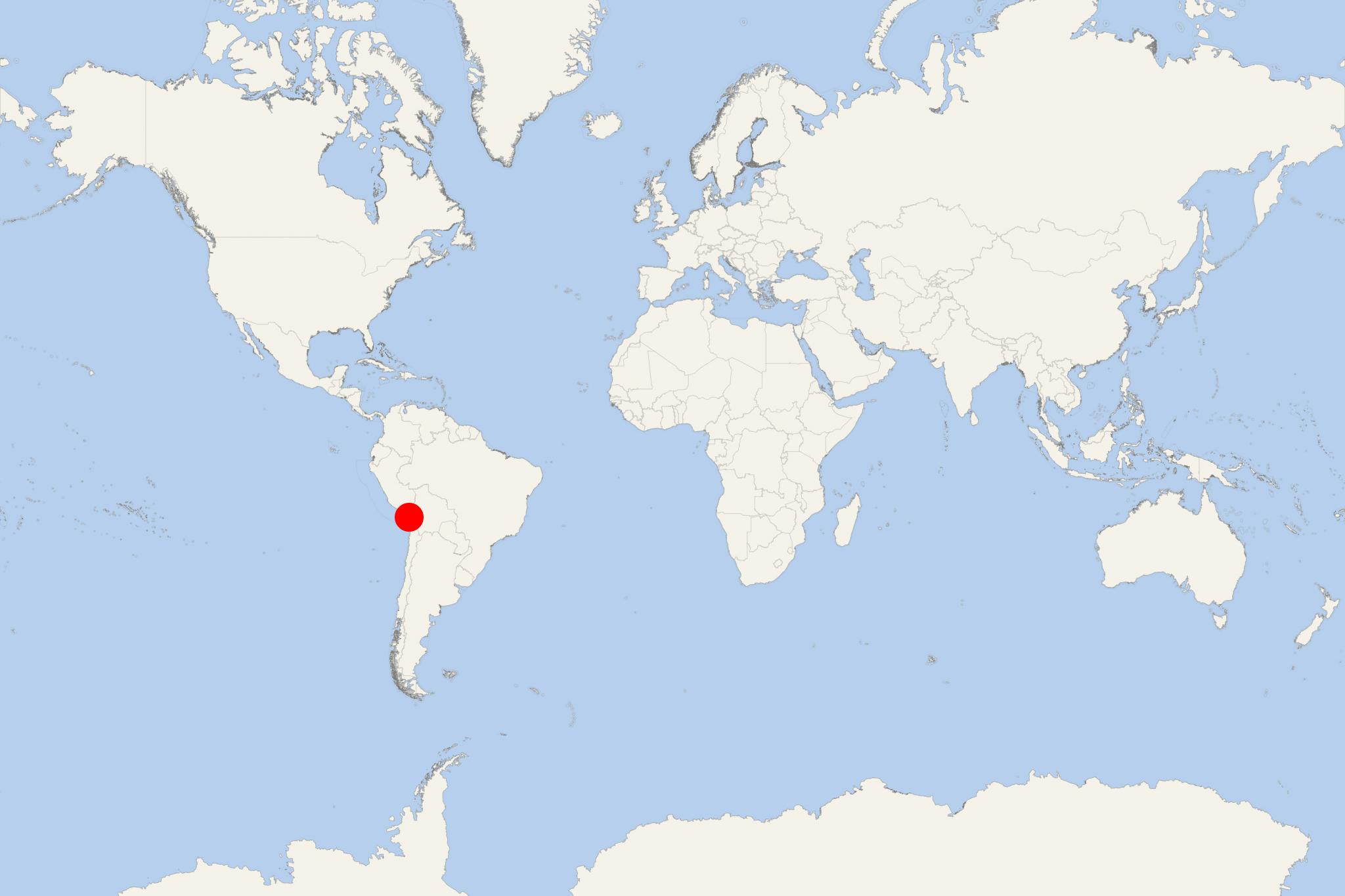
Arica is a commune and port city with a population of around 210,000 (2012 estimate) located in Arica Province, Arica y Parinacota Region in northern Chile. It is the northernmost city in Chile, situated only 18 km (11 miles) south of the border with Peru. The total city area of Arica is 4799 km2 (1853 mi2).
Arica is the capital of both Arica Province and the Arica and Parinacota Region. It lies at the end of the western coast of South America, known as Arica Bend (Arica Elbow). At the city's location, two lush valleys dissect the Atacama Desert converge: Lluta and Azapa. These valleys provide fruit for export.
The city of Arica is an important port for a vast inland region of South America. Arica serves a free port for Bolivia. It also manages a substantial part of the country's trade and is the end station of the Bolivian oil pipeline starting in Oruro. The strategic position of the city is enhanced by being next to Pan-American Highway, connected to both La Paz in Bolivia and Tacna in Peru by railroad and being served by an international airport.
Arica is known as Chile's "city of the eternal spring" due to its mild weather. Its beaches are mostly frequented by Bolivians. During Spanish colonial rule Arica was already a major port already. Following the War of the Pacific, in 1880 Chile seized it from Peru and was recognized as Chilean in 1929. A significant part of African Chileans live in or trace origins to Arica.
At a Glance
Easy independently for central Arica, the waterfront and El Morro. Cruise ships dock in the commercial port close to the city center, but passengers normally use port transport through the secure working area. From the passenger drop-off or port exit, Plaza Colón and the main central sights are within a short walk.
Taxis or an organized tour are more practical for the Anzota Caves, the Azapa Valley and regional attractions. Arica is sunny and exceptionally dry, so carry water and use strong sun protection even when temperatures feel mild.
Getting from the Cruise Port
- Berthing: Ships normally dock rather than tender.
- Leaving the port: Walking through the operational terminal may be restricted. Follow the ship and port instructions for transport to the passenger exit.
- City center: Plaza Colón, San Marcos Cathedral and the former Customs House are generally about 10–20 minutes on foot from the passenger exit, depending on the exact drop-off point.
- Local transport: Taxis are the simplest option for El Morro’s summit, the southern beaches and attractions outside central Arica. Agree on the fare and return arrangements before leaving.
Best Ways to Spend Your Time
Central Arica and El Morro
Allow 2–3 hours. This is the easiest independent option. See Plaza Colón, the metal-framed San Marcos Cathedral, the former Customs House and the pedestrian center before continuing to El Morro de Arica.
The summit stands about 130 meters (427 ft) above the coast and has wide views over the city, port and beaches. The walking approach is steep and exposed to the sun; passengers wanting the views without the climb can take a taxi to the top and walk back into town. Museum access and opening times should be checked locally.
El Laucho and La Lisera Beaches
Allow 2–4 hours. El Laucho is approximately 2–3 km (1.2–1.9 mi) south of central Arica, with La Lisera slightly farther along the coast. A taxi is the easiest choice, although active visitors can walk from the center along the coastal road.
These beaches work well for a relaxed port day, but swimming conditions, lifeguard coverage and facilities can vary. Leave valuables on the ship and confirm a dependable return option if continuing beyond El Laucho.
Anzota Caves
Allow about 2.5–3.5 hours. The Anzota Caves are roughly 12 km (7.5 mi) south of central Arica. A maintained coastal path passes cliffs, sea caves and archaeological landscapes associated with early coastal communities.
Independent with advance transport planning. Public transport is not a reliable cruise-day option, so arrange a taxi with waiting time, a private driver or an organized excursion. The exposed trail can be hot and windy; take water, sun protection and suitable footwear.
Azapa Valley and Chinchorro Heritage
Allow 3–4 hours. The Azapa Valley combines desert scenery, archaeological sites, geoglyphs and the San Miguel de Azapa Archaeological Museum, known for material connected with the ancient Chinchorro culture.
Organized excursion or prearranged transport recommended. The valley and museum are outside practical walking range, and individual sites are dispersed. Confirm that the museum is open on the day of the call before committing to the journey.
Self-Guided City and Morro Walk
Distance: approximately 3.5–4.5 km (2.2–2.8 mi), depending on the passenger drop-off and chosen descent.
Pure walking time: about 60–90 minutes.
Recommended total time: 2.5–3.5 hours.
Difficulty: Moderate, with a steep, exposed ascent to El Morro.
- Passenger drop-off or port exit: Follow the designated route toward the center.
- Former Customs House: View the restored historic building near the waterfront.
- Plaza Colón and San Marcos Cathedral: Pause at Arica’s compact civic center and see the cathedral exterior.
- Central pedestrian streets: Walk through the commercial center for cafés, shops and local activity.
- El Morro approach: Continue toward the marked pedestrian route. Expect a sustained climb, limited shade and sections that may be tiring in the heat.
- El Morro summit: Allow time for the viewpoints, monuments and any museum visit.
- Return: Descend toward Plaza Colón and retrace the short route to the port meeting point. Alternatively, take a taxi from the summit if available.
Passengers who prefer an easy walk can omit El Morro and make a mostly flat circuit through Plaza Colón, the cathedral, former Customs House and central pedestrian streets.
Longer Regional Excursions
Trips toward the Andean highlands, including Lake Chungará and Lauca National Park, involve substantial driving and rapid ascent to very high altitude. They are suitable only for a sufficiently long port call and should be undertaken through a reputable organized excursion. Altitude exposure can be difficult even for fit travelers.
Practical Tips
- Allow extra time to re-enter the secure port area and follow the ship’s stated all-aboard deadline.
- Keep a larger return margin after the Anzota Caves, Azapa Valley or any highland excursion.
- Carry water, sunglasses, a hat and sun protection; shade is limited on El Morro and the coastal trails.
- Confirm attraction opening times locally, particularly for museums and archaeological sites.
- Use registered taxis or transport arranged through the ship, port or an established operator for destinations outside central Arica.
Arica hotels
- Cruise Industry

Scenic Eclipse is the first cruise ship to return at ports along West Coast Central & South America
Scenic Eclipse was greeted with fanfare upon her arrival at numerous Central and South American ports as she made her way down to Antarctica for the...
November 17, 2022 - Cruise Industry
Azamara Announces 2021-2022 Itineraries
Azamara Club Cruises announced the complete list of its 2021 and winter/spring 2022 cruise itineraries. Committed to its Destination Immersion...
April 24, 2019 - show more news