

Bartolome Island (Galapagos)
Cruise Port schedule, live map, terminals, news
Region
Galapagos Islands
Local Time
2026-09-10 22:11
 78°F
78°F 25.7°C

 Mod. breeze
6.4 m/s
 83 °F / 29 °C
 74 °F / 24 °C
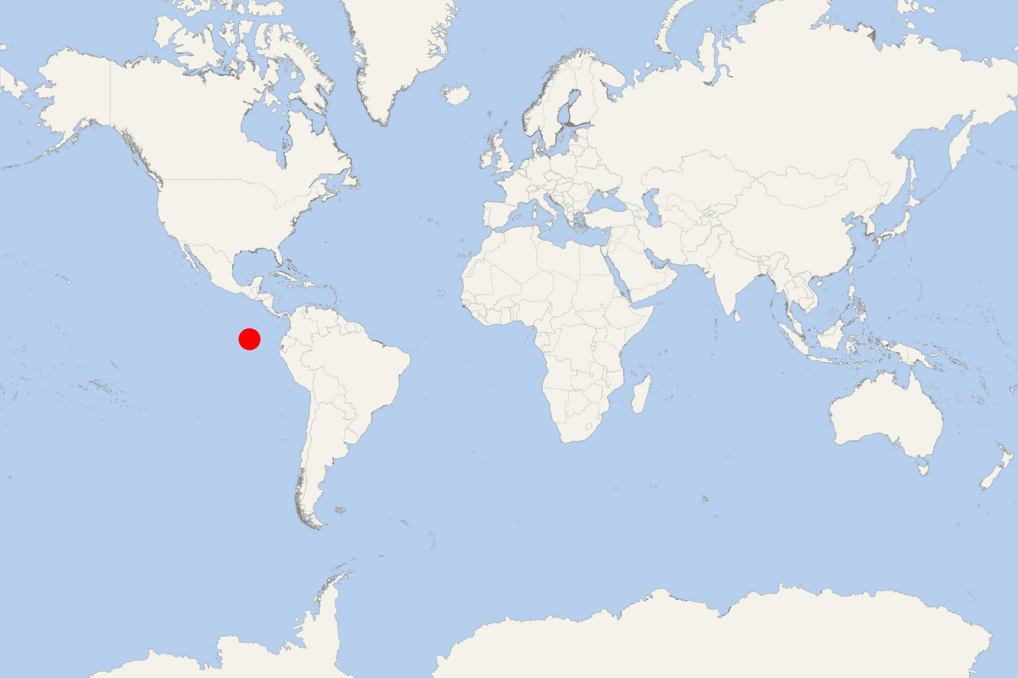
Bartolome Island (Isla Bartolome) is a volcanic islet in the Galapagos Islands group. Bartolome is located off the east coast of Santiago Island and is one of the "younger" isles in the Galapagos archipelago. Bartolome Island, along with Sulivan Bay on Santiago, is named after Sir Bartholomew James Sulivan, naturalist and friend of Charles Darwin, who was a lieutenant on HMS Beagle.
With a land area of just 1.2 km2 (0.5 ml2), Bartolome Island offers some of the prettiest landscapes in the archipelago. It consists of an extinct volcano and various green, red, orange, and shining black volcanic formations. Bartolome features a volcanic cone that is easy to climb and offers great views of the other Galapagos islands.
Bartolome Island is famous for the Pinnacle Rock - the distinctive characteristic of the island, and the representative landmark of Galapagos. Cruisers may swim and snorkel around it as the underwater world there is very impressive. Snorkelers are in the water with white-tipped reef sharks, penguins, marine turtles, and tropical fish. The bay is also a nice place to go swimming.
Bartolome Island cruise terminal
Cruise ships to Bartolome Island (aka Isla Bartolome) dock (anchor) at Puerto Ayora - port town on the southern coast of Santa Cruz Island.
The following map of Galapagos Islands cruise itineraries shows the two main routes and all island stops (ports/landing sites) in the archipelago.
Bartolomé is an uninhabited, protected island in the Galápagos rather than a conventional cruise port. Ships anchor offshore, and passengers visit by Zodiac or panga with an authorized naturalist guide. There is no town, road transport, shopping or independent sightseeing.
Overall practicality: Organized excursion required. Visitors must remain with their guide and follow the landing schedule, marked trails and National Park rules.
Getting Ashore
- Summit trail: Normally reached by a dry landing at a small dock.
- Beach and snorkeling area: Usually reached by a separate wet landing, requiring passengers to step into shallow water.
- Landings and water activities depend on sea conditions and the itinerary authorized for the ship.
- There are no visitor facilities ashore, so bring water, sun protection and everything needed for the outing.
Best Ways to Spend the Call
Climb to the Bartolomé Viewpoint
The island’s principal land activity follows a boardwalk and wooden staircase through a stark volcanic landscape. The trail is approximately 600 m (0.4 mi) each way and climbs about 372 steps to the summit, 114 m above sea level.
Allow roughly 1.5–2 hours for the guided return walk, interpretation stops and time at the viewpoint. The summit overlooks Pinnacle Rock, the island’s twin bays and the lava fields of nearby Santiago Island.
Difficulty: Moderate. The constructed path provides secure footing, but the continuous stairs, exposed sun, heat and lack of shade can make the climb tiring. Passengers with limited mobility or knee problems should discuss the outing with the ship’s expedition team.
Beach Visit and Snorkeling
If included in the ship’s program, a wet landing may lead to beach time, swimming or guided snorkeling near Pinnacle Rock. Marine turtles, rays, reef fish, sea lions and Galápagos penguins may be encountered, but sightings are never guaranteed.
Water temperature, visibility and currents vary. Follow the expedition team’s instructions and use the flotation equipment offered if needed. Non-snorkelers may be able to remain on the designated beach, depending on current National Park access and conditions.
Guided Panga Exploration
Some itineraries include a small-boat ride along the shoreline to examine volcanic formations and look for seabirds, penguins or other marine wildlife. This is a practical alternative when a landing is unsuitable or for passengers who prefer not to make the summit climb, but availability is determined by the ship.
Can You Explore Independently?
No. Bartolomé has no public passenger landing, independent trail access or local transport. Visits to this protected National Park site must be conducted with an authorized naturalist guide. Cruise passengers should use the excursion arranged by their expedition ship rather than attempt to organize separate transport.
Practical Tips
- Wear secure walking shoes for the summit trail and bring suitable footwear for a possible wet landing.
- Carry water, a hat and strong sun protection; the volcanic terrain is exposed and largely without shade.
- Keep at least 2 m (6.6 ft) from wildlife, stay on marked routes and do not touch or feed animals.
- Use only photography without flash and follow the guide’s instructions around wildlife.
- Protect cameras and phones from spray during Zodiac transfers.
- Return timing is managed by the ship’s expedition team. Do not separate from the group or remain ashore after the instructed meeting time.
Bartolome Island hotels
- Cruise Industry
Cunard unveils extended shore excursions for South America 2025 voyages
Cunard Line has announced an array of extended shore excursions as part of its return to South America in 2025, marking its first operation in the...
September 26, 2024 - Cruise Industry
Silversea restarts Galapagos Islands' cruises on June 19
Silversea Cruises announced its return to service in the Galapagos Islands aboard the new ship Silver Origin, which arrived in San Cristobal on April...
May 12, 2021 - show more news