

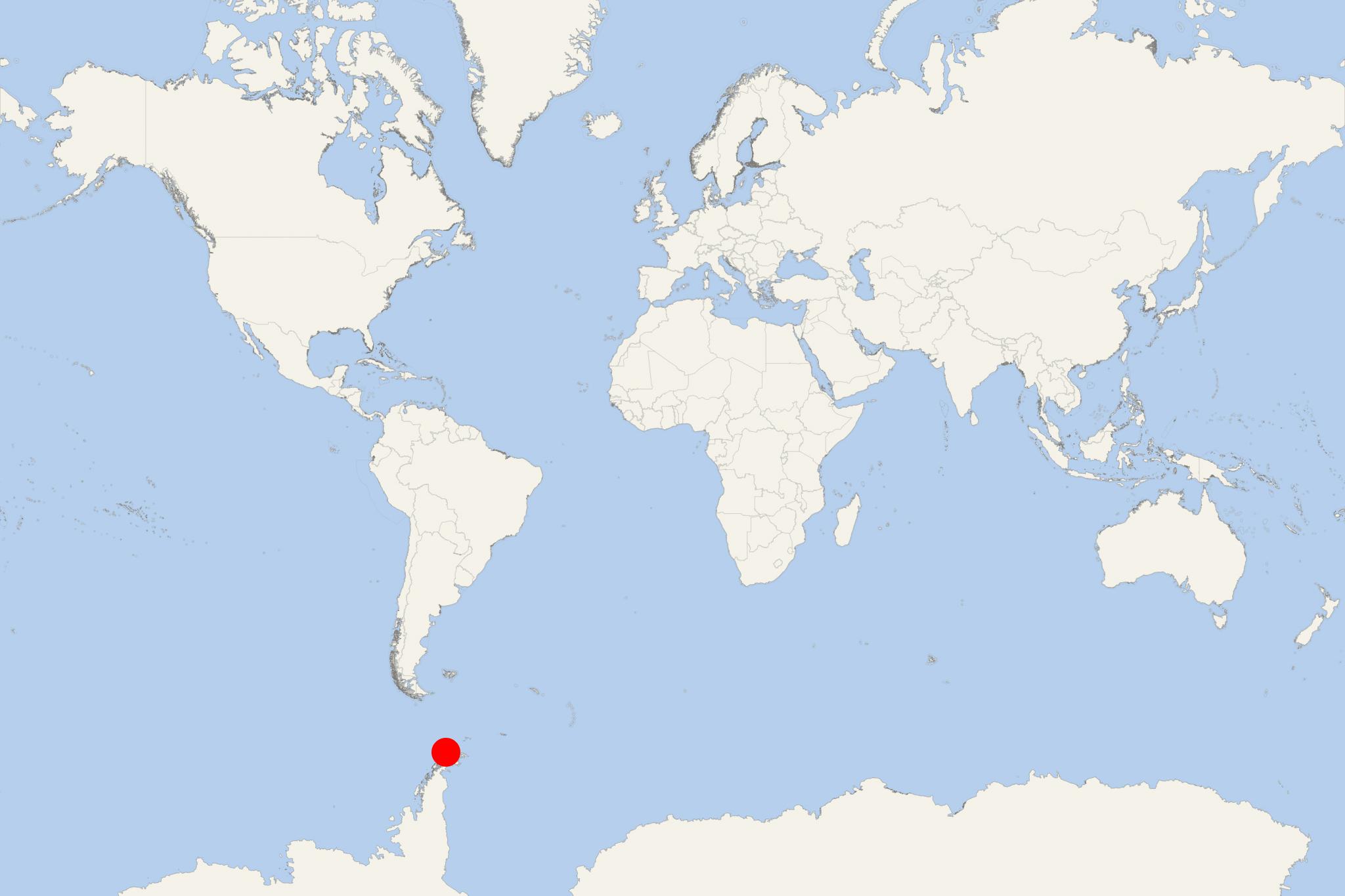
Deception Island Antarctica (South Shetlands)
Cruise Port schedule, live map, terminals, news
Region
Arctic - Antarctica
Local Time
2026-10-21 16:11
 31°F
-0.5°C

 Near gale
14.4 m/s
 33 °F / 1 °C
30 °F / -1 °C
Port Deception Island Antarctica cruise ship schedule shows timetable calendars of all arrival and departure dates by month. The port's schedule lists all ships (in links) with cruises going to or leaving from Deception Island Antarctica, South Shetlands. To see the full itineraries (ports of call dates and arrival / departure times) and their lowest rates – just follow the corresponding ship-link.
| Day | Ship | Arrival | Departure |
|---|---|---|---|
| 18 January, 2028 Tuesday |  MS Hamburg |
Deception Island is one of the South Shetland Islands, located north of Antarctic Peninsula. The island has one of Antarctica's safest harbours. It is ring-shaped caldera, which is the top of an active volcano. The caldera's diameter is approx 15 km (9 ml). Neptune’s Bellows is the name of the narrow entrance to the harbor.
The island is the caldera of an active volcano that damaged local scientific stations in 1967 and in 1969. Previously, the isle held a whaling station. Today, it is a scientific outpost with Spanish and Argentine research bases on it.
The island is uninhabited but became a popular tourist destination in Antarctica due to its chinstrap penguin colonies and the possibility of making warm baths by digging into the sands of its beach. Wildlife is not abundant, but still, several breeding bird species can be seen on the cliffs. At the Bailey Head peninsula (outside western coast) can be seen about 50.000 Chinstrap Penguin pairs.
Mount Flora is the first Antarctic site where fossilized plants have been discovered. There is a geothermal activity that generates seawater temperatures of up to 70 C. Volcano's last eruptions were recorded in 1969.
On January 30, 2007, the Hurtigruten cruise ship MS Nordkapp ran aground off Deception Island's coast. As result from the grounding accident, fuel from the vessel washed into the bay. Ecological damage has not been determined yet. On February 4, 2007, Gabriel de Castilla research station reported that sand and water tests were clean.
Deception Island Antarctica cruise terminal
Cruise ships to Deception Island anchor in the Port Foster bay. At Whalers Bay (near the Neptune’s Bellows entrance) still can be seen the remains of a British scientific station (evacuated after the last volcano eruption).
Deception Island is an expedition landing destination inside an active volcanic caldera. The main experiences are black volcanic beaches, abandoned whaling buildings, crater walks and, where conditions permit, penguin watching. Independent sightseeing is limited: all access is arranged by your ship, and walking ashore takes place within areas approved and supervised by expedition staff.
Getting Ashore
Ships visiting the caldera enter Port Foster through Neptune’s Bellows and normally anchor rather than dock. Passengers go ashore by Zodiac or another small expedition boat, usually with a wet beach landing. There is no conventional cruise terminal, town, public transport or taxi service.
Your expedition team selects the landing site and sets the time ashore. Wind, sea conditions, volcanic safety assessments and wildlife can change or cancel activities. A scheduled call does not guarantee a landing; vessels carrying more than 500 passengers cannot land passengers in Antarctica.
Whalers Bay, Telefon Bay, Pendulum Cove and Baily Head are separate landing options, not stops on an independent island circuit. Expect to take part in the activity offered that day rather than combine them yourself.
Best Ways to Spend Your Time
Whalers Bay: Volcanic Beach and Historic Remains
Whalers Bay suits passengers who prefer a relatively gentle shore visit. Explore the ash beach and view the old whaling boilers, fuel tanks, cemetery and abandoned British station buildings from outside. Allow roughly 1–2 hours if your landing slot permits. Walking is mostly gently sloping, but loose ash, stones and meltwater streams make the footing uneven. Entry into buildings is prohibited.
If staff open the route, continue along the beach to Neptune’s Window, a gap in the cliffs overlooking the island’s outer coast. This adds an uphill section on loose ground; follow existing paths and keep well back from the unstable cliff edge. It is an optional supervised extension, not an unrestricted hike.
Telefon Bay: Guided Crater Walk
Choose the crater walk if offered and you are comfortable climbing on loose volcanic material. The landing beach leads into a valley with a steeper ascent towards the craters. Budget approximately 1–2 hours for a beach visit and guided walk, subject to the expedition timetable.
The higher ground offers views of the volcanic landscape and Port Foster. Crater edges can crumble, so stay with the guided group. Passengers wanting less exertion may be able to remain in the supervised beach area; confirm arrangements before leaving the ship.
Baily Head: Chinstrap Penguin Watching
Baily Head, on the island’s exposed outer coast, is the principal option for seeing a large chinstrap penguin colony. Landings depend strongly on surf and weather and may not be possible even when conditions inside Port Foster are suitable.
A visit can include beach observation and a guided walk towards the colony. The valley rises inland, with uneven ground and a meltwater stream; routes and duration depend on wildlife and conditions. Keep penguin commuting paths clear and follow staff instructions rather than choosing your own approach.
Pendulum Cove: Geothermal Shoreline
If included in your expedition programme, Pendulum Cove offers a gently sloping volcanic beach and views of the ruined Chilean station. Treat this as a short supervised shoreline visit rather than a bathing destination.
Geothermally heated water can be hot enough to cause scalding. Enter the water only if the operator specifically arranges and supervises the activity. Do not dig bathing pits, enter the station ruins or continue inland beyond them.
Walking Ashore
There is no suitable independent self-guided walking tour. At Whalers Bay, expedition staff may allow you to explore a defined area at your own pace, but boundaries, wildlife detours and return times remain controlled. Crater walks and visits around sensitive ruins require closer guidance.
Choose the shorter beach option if loose surfaces, slopes or wet landings are difficult for you. Even a relatively level landing involves stepping between a moving boat and the shore; discuss mobility needs with the expedition team beforehand.
Practical Tips
- Wear the operator’s recommended waterproof boots, waterproof outer layers, warm clothing and gloves. Protect cameras from spray during boat transfers.
- Complete the ship’s boot and equipment cleaning procedures before and after landing.
- Give wildlife space and right-of-way. Follow the distances set by guides, including any additional seasonal restrictions.
- Leave bones, stones and historic objects untouched. Avoid vegetation, scientific instruments and marked protected areas.
- Return to the designated boat pickup point before your group’s deadline. Keep enough time for the walk back; transfers may finish early if conditions deteriorate.
- If landing is cancelled, use the ship’s viewing decks for caldera scenery and attend the expedition team’s geology and history briefings.
Deception Island Antarctica hotels
- Accidents
Engine failure disrupts Antarctic cruise on Swan Hellenic's ship SH Diana
Passengers aboard Swan Hellenic’s expedition ship SH Diana have experienced significant disruptions during a 20-night repositioning voyage from...
November 29, 2024 - Cruise Industry
AOV-Atlas Ocean Voyages open bookings for 18 cruises on World Voyager ship
AOV-Atlas Ocean Voyages, a leading provider of superyacht-style expedition cruises, has opened reservations for 18 expeditions on their 3rd vessel...
May 19, 2023 - Cruise Industry
Atlas Ocean Voyages unveils World Navigator’s Inaugural Antarctica season (November 2021)
AOV-Atlas Ocean Voyages announced that the luxe-adventure brand would proceed with the inaugural Antarctica season for AOV's first newbuild...
September 17, 2021 - Cruise Industry
NCL-Norwegian Cruise Line's Extraordinary Journey itineraries 2021-2022-2023
NCL-Norwegian Cruise Line opened bookings for itineraries in 2021-2022-2023, with 20+ new cruise port destinations across the 7 continents...
May 11, 2020 - Cruise Industry
Atlas Ocean Voyages ship World Navigator inaugural 2021-2022 Antarctica cruises
Atlas Ocean Voyages unveiled its inaugural winter 2021-2022 Antarctica-season itineraries. Beginning November 19, 2021, the small line brand AOV...
May 8, 2020 - show more news