Champ Island (Arctic Russia)
Cruise Port schedule, live map, terminals, news
Region
Arctic - Antarctica
Local Time
2025-09-11 21:09
 26°F
26°F -3.5°C

 Very Light
0.9 m/s
 33 °F / 1 °C
 22 °F / -5 °C
Champ Island (Ostrov Champ) is an uninhabited island in central Franz Josef Land (archipelago in Arctic Russia), with land area 374 km2 (144 mi2) and highest elevation point 507 m (1663 ft).
The island is neighboured by Luigi Island (north) and Salisbury Island (northeast).
Champ Island is best known for its numerous ball-shaped stones - perfectly round spheres ranging in diameter from millimeters to several meters. There is no official version about boulders' origins.
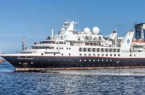
The island was visited by the cruise ship Silver Explorer during Silversea Expeditions' Northwest Passage cruise in 2019 (Aug 10 - Sept 6).
| Date / Time | Port |
|---|---|
| 10 Aug | Departing from Nome, Alaska |
| 12 Aug | International Date Line crossing |
| 13 Aug 10:00 - 16:00 | Provideniya, Chukotka, Russia |
| 14 Aug 14:00 - 18:00 | Uelen, Chukotka, Russia |
| 15 Aug 15:00 - 20:00 | Kolyuchin Island, Russia |
| 16-17-18 Aug | Wrangel Island, Arctic Russia |
| 19-20 Aug | Chukotka Peninsula, Russia (Overnight) |
| 21 Aug 05:00 - 12:00 | Bear Islands, Arctic Russia |
| 22-23-24-25 Aug | At Sea |
| 26 Aug 07:00 - 14:00 | Severnaya Zemlya, Arctic Russia |
| 27 Aug | At Sea |
| 28 Aug 06:00 - 13:00 | Uyedineniya Island, Arctic Russia |
| 29 Aug 07:00 - 12:00 | Novaya Zemlya, Arctic Russia |
| 30 Aug 14:00 - 21:00 | Franz Josef Land, Arctic Russia |
| 31 Aug | Champ Island, Russia |
| 31 Aug | Hooker Island, Arctic Russia |
| 01 Sep 05:00 - 11:00 | Franz Josef Land, Arctic Russia |
| 02 Sep - 03 Sep | At Sea |
| 04 Sep 11:00 - 17:00 | Murmansk, Arctic Russia |
| 05 Sep 14:00 - 19:00 | Gjesvaerstappan Island, Norway |
| 06 Sep | Arriving in Tromso, Norway |
The 26-day itinerary covered a distance of 5780 ml (9300 km),
- Cruise Industry

Silversea's Silver Explorer to Cruise Northeast Passage 2019
Silversea Expeditions is currently celebrating its 10th anniversary with the first for the line Northeast Passage crossing. The route transits Arctic...
July 19, 2018 - show more news
